Located in the extreme northwest of North America, the state of Alaska has earned the nickname, “The Last Frontier,” for its remote location and its status as the second-youngest state in the US. It’s also known for its incredible natural beauty, which includes some of the largest glaciers in the world, pristine sea fjords, and striking mountains.
Alaska is the biggest state in the US, and it’s one of only two that doesn’t divide its territory into counties. Instead, the largest administrative divisions used in Alaska are boroughs and census areas. In this post, we’ll look at a map of Alaska’s boroughs and census areas as well as some of their most interesting features.
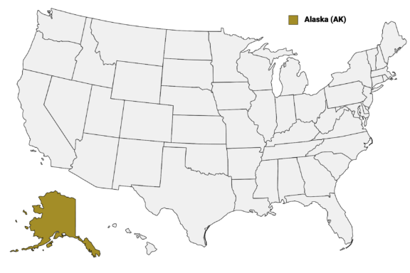
Alaska (AK) on the US Map
Alaska’s Boroughs and Census Areas
The Constitution of Alaska, ratified in 1956, states that the state “shall be organized into boroughs, organized or unorganized.” Alaska is the only state in the US that uses boroughs for its largest administrative division.
There are 19 organized boroughs in Alaska and one Unorganized Borough, the latter of which comprises 11 census areas. The Unorganized Borough is noncontiguous and consists of all land that isn’t part of an organized borough. This land is typically less populated.
The organized boroughs function much like counties in other states; they have their own local governments. The census areas in the Unorganized Borough were created by the US Census Bureau and are only used for statistical analysis.
Below is a map of the 30 county-equivalents (boroughs) of Alaska (you can click on the map to enlarge it and to see the major city in each state).

Interactive Map of Alaska Boroughs
Click on any of the counties on the map to see its population, economic data, time zone, and zip code (the data will appear below the map). Data is sourced from the US Census 2021.
List of the Counties/Boroughs of Alaska:
| County | Population | Per sq. km | Largest City |
|---|---|---|---|
| Aleutians East Borough | 3,409 | 0.19 | King Cove |
| Aleutians West Census Area | 5,251 | 0.46 | Unalaska |
| Anchorage Municipality | 292,545 | 66.17 | Anchorage |
| Bethel Census Area | 18,514 | 0.18 | Bethel |
| Bristol Bay Borough | 849 | 0.68 | King Salmon |
| Chugach Census Area | 7,015 | 0.28 | Valdez |
| Copper River Census Area | 2,635 | 0.04 | Tazlina |
| Denali Borough | 2,187 | 0.07 | Healy |
| Dillingham Census Area | 4,899 | 0.1 | Dillingham |
| Fairbanks North Star Borough | 97,149 | 5.11 | Fairbanks |
| Haines Borough | 2,098 | 0.35 | Haines |
| Hoonah-Angoon Census Area | 2,327 | 0.14 | Hoonah |
| Juneau City and Borough | 32,240 | 4.6 | Juneau |
| Kenai Peninsula Borough | 58,711 | 1.42 | Kalifornsky |
| Ketchikan Gateway Borough | 13,939 | 1.11 | Ketchikan |
| Kodiak Island Borough | 13,218 | 0.76 | Kodiak |
| Kusilvak Census Area | 8,354 | 0.19 | Kotlik |
| Lake and Peninsula Borough | 986 | 0.02 | Port Alsworth |
| Matanuska-Susitna Borough | 106,807 | 1.67 | Knik-Fairview |
| Nome Census Area | 10,070 | 0.17 | Nome |
| North Slope Borough | 10,865 | 0.05 | Utqiagvik |
| Northwest Arctic Borough | 7,776 | 0.08 | Kotzebue |
| Petersburg Borough | 3,368 | 0.45 | Petersburg |
| Prince of Wales-Hyder Census Area | 5,886 | 0.43 | Metlakatla |
| Sitka City and Borough | 8,518 | 1.15 | Sitka |
| Skagway Municipality | 1,329 | 1.18 | Skagway |
| Southeast Fairbanks Census Area | 6,849 | 0.11 | Deltana |
| Wrangell City and Borough | 2,162 | 0.33 | Wrangell |
| Yakutat City and Borough | 562 | 0.03 | Yakutat |
| Yukon-Koyukuk Census Area | 5,433 | 0.01 | Fort Yukon |
The Largest Alaskan Boroughs by Population
Municipality of Anchorage

The municipality of Anchorage is a consolidated city-borough, meaning the border of the city and the borough are coterminous. The city of Anchorage was incorporated in 1920, and it merged with the Greater Anchorage Area Borough in 1975 to form the city-borough that exists today.
Anchorage is the largest city-borough in Alaska by a large margin. It’s got more than twice as many residents as the next largest borough with 292,545 people, and it’s the largest city in the state, though it isn’t the state capital.
The bustling urban center of Anchorage exists in stark contrast to the surrounding Alaskan wilderness, and it’s a great jumping-off point for exploring the state’s nature. The nearby Chugach State Park is one of the four largest state parks in the country and is full of rugged, diverse topography.
Indigenous groups of Alaska Natives play a central role in the history of humans in the area, arriving as early as 14,000 years ago. One way to learn more about the cultural heritage of Indigenous people in the area is to visit the Alaska Native Heritage Center in Anchorage
Matanuska-Susitna Borough

The second-most populous borough in Alaska is the Matanuska-Susitna Borough, with a population of 106,807. Often shortened to Mat-Su Borough, it gets its name from the Matanuska and Susitna rivers, which exist entirely within the borough and empty into the Cook Inlet at the borough’s southern border.
Along with the Municipality of Anchorage, the Mat-Su Borough is part of the Anchorage Metropolitan Statistical Area, which is home to more than half of the state’s population. The borough seat is Palmer, Alaska’s ninth-largest city and the site of the Alaska State Fair. The Dena’ina and Ahtna Athabaskans were the first peoples to live in the area of present-day Palmer.
As is the case with the majority of locations in Alaska, amazing wilderness is easily accessible from the Mat-Su Borough. Chugach National Forest, Denali National Park and Preserve, and Lake Clark National Park and Preserve are all at least partially located in the borough.
The Matanuska Glacier State Recreation Area is a favorite among outdoor lovers. Hiking, glacier trekking, and river rafting are possible in the summer months, and winter allows for snowshoeing and skiing.
Fairbanks North Star Borough

With a total land area that’s slightly smaller than the state of New Jersey, Fairbanks North Star Borough had a population of 97,149 in 2021, making it the third most populous borough in Alaska. It is located in Interior Alaska in the central-eastern part of the state.
The borough seat is the city of Fairbanks, which gets its name from Charles Fairbanks, a former US senator and vice president. Fairbanks is the second-largest city in Alaska and the largest in its Interior region. Home to the University of Alaska and its own international airport, Fairbanks offers attractions to tourists such as winter sports, seeing the northern lights, and easy access to the state’s rugged interior.
The Fairbanks North Star Borough is also designated as the Fairbanks Metropolitan Statistical Area, which is one of only two metropolitan areas in Alaska and the northernmost metropolitan statistical area in the US. Just under 100,000 people live here.
Kenai Peninsula Borough

Located to the south and west of the Municipality of Anchorage, the Kenai Peninsula Borough is the fourth-largest Alaskan borough by population — there were 58,711 living here in 2021.
The borough covers most of the Kenai Peninsula, whose name comes from the word “Kenaitze,” a name for the Native Kahtnuht’ana Dena’ina tribe that historically inhabited the area. The Kenaitze Tribe’s name for the peninsula is Yaghanen, which translates to “the good land” in English.
The borough seat of the Kenai Peninsula Borough is Soldotna, located on the central-western part of the peninsula, and the most populous locality in the borough is the census-designated place of Kalifornsky.
There are many popular natural attractions in the area of this borough, such as Kenai Fjords National Park, where nearly 40 glaciers flow from the Harding Icefield. There are also excellent salmon fishing opportunities in the area, helping the region to earn the name, “Alaska’s Playground.”
Juneau City and Borough

Juneau is a consolidated city-borough and the capital of Alaska. It is situated on the Alaskan Panhandle and is the second-largest city in the US by area, covering a total area of 3,254.70 sq mi (8,429.64 km2).
The Native Tlingit people had inhabited the area of present-day Juneau and fished for salmon for centuries before the arrival of Europeans at the end of the 18th century. The presence of gold later brought prospectors into the area around 1880, and Juneau was named after prospector Joe Juneau in 1881.
Juneau is surrounded by mountains, glaciers, and pristine waters, making it something of an outdoor paradise. The city is located on the coast, which provides it with whale-watching, kayaking, and fishing opportunities. It also provides access to the stunning Mendenhall Glacier and the Tongass National Forest.
There are also cultural attractions in Juneau, such as the Alaska State Museum, which includes cultural material from many Native Alaskan Tribes from all across the state. The Alaska State Capitol building is also located in Juneau and is home to the offices of the Governor of Alaska and Lieutenant Governor of Alaska as well as the Alaska Legislature.
Largest Census Areas in Alaska by Population
All of Alaska’s census areas are technically a part of the state’s Unorganized Borough, which comprises the land not claimed by any organized borough. There are 11 census areas, and we’ll look at the three most populous below.
Bethel Census Area
With a population of 18,514 in the 2021 census, Bethel is the largest census area in Alaska by population. The largest city is Bethel, but there is no borough seat as it is a census area and therefore part of the larger Unorganized Borough of Alaska. Bethel is also the largest city in the Unorganized Borough.
Situated in the southwestern part of Alaska, the Bethel Census Area covers an extensive area and includes Nunivak Island. Tundra, boreal forests, rivers, lakes, and wetlands are some of the diverse landscapes found in the area. Bordering census areas include the Yukon-Koyukuk Census Area, the Nome Census Area, and the Dillingham Census Area.
The majority of the population in the Bethel Census Area consists of Alaska Native peoples such as the Yup’ik, Cup’ik, and Athabascan communities. As the largest city in the area, Bethel serves as a hub for essential services and transportation connections, and it is administered by the Orutsararmiut Traditional Native Council.
Nome Census Area

The Nome Census Area is located in the western part of Alaska, mostly overlapping with the Seward Peninsula, and includes the large offshore St. Lawrence Island. It had a population of just over 10,000 in 2021, making it the seventh-largest county-equivalent in the state of Alaska.
Although there is no borough seat in the Nome Census Area, the largest city is Nome. One of Nome’s claims to fame is being the endpoint of the Iditarod Dog Sled Race, which traces the route of the 1925 Serum Run of Nome that saved the community from a diphtheria epidemic.
The area around present-day Nome was inhabited by the Inupiat, whose ancestors crossed the Bering Land Bridge from Siberia thousands of years ago. Gold was discovered by Europeans in 1898 at Anvil Creek near Nome, which caused rapid growth in the area’s population.
Today the city of Nome acts as an administrative hub for the region and provides essential services such as healthcare, education, and transportation connections. Much of the transportation through the rugged terrain in the Nome Census Area happens by air travel and waterways.
Kusilvak Census Area
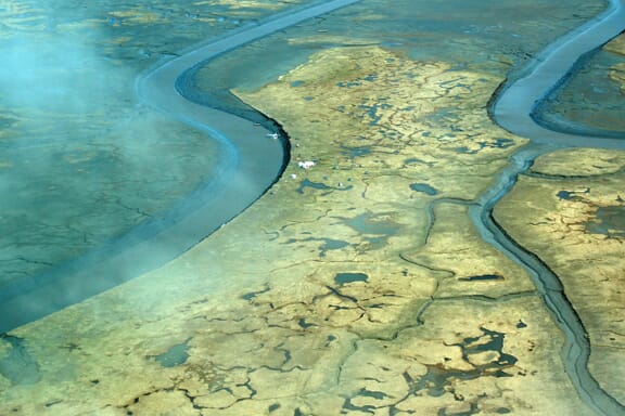
The Kusilvak Census Area has the third-highest population of census areas in Alaska’s Unorganized Borough. It is located in the western part of the state on the Bering Sea coast and covers a total area of 19,673 sq mi (50,950 km2).
This census area was formerly known as the Wade Hampton Census Area, named after a politician from South Carolina. Feeling that the former slave-owning politician who had never been to Alaska was not a good representative for the area, residents pushed to change the name. In 2015, Governor Bill Walker renamed the census area after the Kusilvak Mountains.
One of the largest population centers in the Kusilvak Census Area is Hooper Bay. The vast majority of the population in this census area is of American Indian or Alaska Native descent. Hooper Bay Elementary School has a Yup’ik language immersion program for students from kindergarten up to third grade.
The Smallest Boroughs in Alaska by Population
Yakutat City and Borough

Yakutat is a consolidated city-borough in southeastern Alaska, covering part of the Alaskan Panhandle. It is the smallest county-equivalent in Alaska by population, though in area it is six times larger than the state of Rhode Island. The former City of Yukatat, now a census-designated place, is the largest population center in the area.
The name of this borough in the Tlingit language is Yaakwdáat, which translates to “the place where canoes rest.” Eyak and Tlingit peoples were residing in the area of the present-day borough of Yakutat before the arrival of Europeans in the 18th century.
The primary economic activity in Yakutat is fishing, and there is a private airport located in Icy Bay, the only other significant population center in the borough.
Bristol Bay Borough

Bristol Bay Borough is the second smallest borough in Alaska in terms of population and total area. The small borough consists of a rectangle of land surrounding Naknek, the borough seat, and King Salmon. Although King Salmon is located in Bristol Bay Borough, it is the borough seat of neighboring Lake and Peninsula Borough.
The borough borders Kvichak Bay and includes the Naknek River which connects the bay to Naknek Lake. The borough also includes part of the Katmai National Park and Preserve, which is notable for its Valley of Ten Thousand Smokes and its brown bears.
Notable Alaskan Boroughs and Census Areas
Sitka City and Borough

The name Sitka is derived from a Tlingit contraction meaning “People on the Outside of Baranof Island.” The unified city-borough is located in southeastern Alaska, on the western part of Baranof Island. It was under Russian rule from 1799 until the Alaska Purchase of 1867 and functioned as the capital of Russian America.
Sitka became the first capital of Alaska after the transfer from Russia to the United States. Today, Sitka is a popular location for travelers interested in checking out the incredible wilderness in the area. The scenery, fishing, and hiking opportunities are all top attractions.
Aleutians West Census Area

The Aleutians West Census Area covers most of the Aleutian Islands, a chain of islands that extends into the northern Pacific Ocean. The archipelago divides the Bering Sea to the north from the Pacific Ocean to the South. Most of the islands are part of Alaska, 15 are volcanic, and a minority belong to the Russian state of Kamchatka Krai.
There is no borough seat in this census area, but the largest city is Unalaska, located on Unalaska Island. After Bethel, this is the largest city in Alaska’s Unorganized Borough. Native Unangan people have inhabited Unalaska for thousands of years.
The national protected areas in this census area include the Alaska Maritime National Wildlife Refuge and the Aleutian World War II National Historic Area.
More About Alaska
How many Alaska counties are there?
There are 30 county-equivalents in Alaska, classified as boroughs and census areas.
What is the smallest county in Alaska?
The smallest county in Alaska by population is Yakutat City and Borough. The smallest county in Alaska by size is Skagway Municipality.
What is the coldest city in Alaska?
The coldest city in Alaska is Utqiagvik, which has an average minimum temperature over the year of 6° Fahrenheit (-14.4° Celsius). Utqiagvik, formerly known as Barrow, is also Alaska’s most northerly city.
Image Sources and Copyright Information
- Administrative Map of Alaska Showing Boroughs and Census Areas: © Mapcorn/Shutterstock
- Aerial View of Downtown Anchorage, Alaska Skyline with Mountain Backdrop: © Jacob Boomsma/Shutterstock
- Autumnal Panorama of the Matanuska River and Surrounding Mountains in Alaska: © Chansak Joe/Shutterstock
- Aerial View of Downtown Fairbanks, Alaska at Twilight: © Jacob Boomsma/Shutterstock
- Orca Breaching with a Misty Spout Against a Backdrop of Alaskan Mountains and Glaciers: © Troutnut/Shutterstock
- Aerial View of Downtown Juneau, Alaska with Mountains and Waterways: © Tim Hancock/Shutterstock
- Nome City Hall Building in Nome, Alaska with Clear Blue Sky: © Andrew F. Kazmierski/Shutterstock
- Aerial View of the Meandering Waterways Along the Bering Sea Coast in Kusilvak Census Area: © Becker, Don/USGS EROS - U.S. Fish and Wildlife Service | Public Domain Mark 1.0
- Majestic Glacier Front with Snow-Capped Mountains in Disenchantment Bay, Yakutat, Alaska: © Claudine Van Massenhove/Shutterstock
- Floatplane Approaching a Dock on the Naknek River in Bristol Bay Borough: © CSNafzger/Shutterstock
- Tranquil Waterfront View of Sitka, Alaska with Snow-Capped Mountains and Cloud-Flecked Sky: © Jnjphotos/Shutterstock
- Sunset Glow on the Snow-Capped Great Sitkin Volcano in the Aleutian Chain, Alaska: © photomatz/Shutterstock