Comoros is located in the Northern Africa region at latitude -11.875001 and longitude 43.872219 and is part of the African continent.
The DMS coordinates for the center of the country are:
- 11° 52' 30.00'' S
- 43° 52' 19.99'' E
You can see the location of Comoros on the world map below:
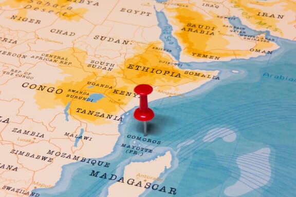
The country has no neighboring countries/land borders.
Maritime Borders
Comoros borders with the Indian Ocean.
Comoros (the) Related Content
Comoros Key Facts
| Country | Comoros (the) |
| Coordinates | Latitude: -11.875001 Longitude: 43.872219 |
| Country Codes | Alpha 2: KM Alpha 3: COM |
| Country Flag Emoji | 🇰🇲 |
| Int. Phone Prefix | +269 |
| Capital city | Moroni |
| Continent Subcontinent | Africa Northern Africa |
| Country Area | 2235 sq km |
| Population 2021 | 888,456 World Rank: 159 |
| Median Age | 20.1 |
| Life expectancy | 63.4 |
| Major languages | Comorian, French |
| UTC/GMT Time | Number of time zones: 1
|
| Internet TLD | .km |
| Biggest Airport | Prince Said Ibrahim International Airport (Grande Comore) |
| Average temperature | 27.00 °C 80.60 °F |
| Administrative Divisions | 3 islands |
| Political system | Federal presidential representative democratic republic |
Comoros Economy Facts
| World Bank Income Group | Lower middle income |
| World Bank Region | Sub-Saharan Africa |
| Currency | Comoros Franc (KMF) |
| GDP in 2020 | $0.9 (billions of USD) World Rank: 182 |
| GDP per capita in 2020 | $1,407 World Rank: 159 |
| Major Industries / Economic Sectors | Agriculture, fishing, manufacturing, energy |
| Top 5 Import Countries | France, China, India, United Arab Emirates, Saudi Arabia |
| Top 5 Export Countries | France, United Arab Emirates, Tanzania, India, Japan |
Biggest Cities in Comoros
Here are the largest cities in Comoros based on 2021 data:
| City | Population |
|---|
| Moroni | 111,329 | Mutsamudu | 30,000 | Mkazi | 8,438 | Mitsamiouli | 7,235 |
Map of Comoros with the Largest Cities
Other Countries in the Northern Africa Region
- Where is Algeria?
- Where is Benin?
- Where is Burkina Faso?
- Where is Cabo Verde?
- Where is Cameroon?
- Where is Chad?
- Where is Djibouti?
- Where is Egypt?
- Where is Equatorial Guinea?
- Where is Eritrea?
- Where is Ethiopia?
- Where is Gabon?
- Where is Gambia?
- Where is Ghana?
- Where is Guinea-Bissau?
- Where is Guinea?
- Where is Ivory Coast (Côte d’Ivoire)?
- Where is Liberia?
- Where is Libya?
- Where is Mali?
- Where is Mauritania?
- Where is Morocco?
- Where is Niger?
- Where is Nigeria?
- Where is Sao Tome and Principe?
- Where is Senegal?
- Where is Sierra Leone?
- Where is Somalia?
- Where is Sudan?
- Where is the Central African Republic?
- Where is Togo?
- Where is Tunisia?