Eritrea is located in the Northern Africa region at latitude 15.179384 and longitude 39.782334 and is part of the African continent.
The DMS coordinates for the center of the country are:
- 15° 10' 45.78'' N
- 39° 46' 56.40'' E
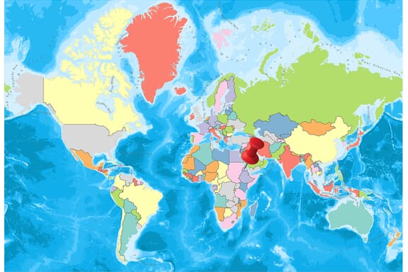
You can see the location of Eritrea on the world map below:
Eritrea Neighboring Countries
The neighboring countries of Eritrea (ER) are:
- Djibouti (DJ)
- Ethiopia (ET)
- Sudan (SD)
Maritime Borders
Eritrea borders with the Red Sea.
Eritrea Related Content
Eritrea Key Facts
| Country | Eritrea |
| Coordinates | Latitude: 15.179384 Longitude: 39.782334 |
| Country Codes | Alpha 2: ER Alpha 3: ERI |
| Country Flag Emoji | 🇪🇷 |
| Int. Phone Prefix | +291 |
| Capital city | Asmara |
| Continent Subcontinent | Africa Northern Africa |
| Country Area | 117,600 sq km |
| Population 2021 | 6,209,000 World Rank: 111 |
| Median Age | 18.2 |
| Life expectancy | 66.5 |
| Major languages | Tigrinya (official), Arabic (official), English (official), Tigre, Kunama, Afar, other Cushitic languages |
| UTC/GMT Time | Number of time zones: 1
|
| Internet TLD | .er |
| Biggest Airport | Asmara International Airport (ASM) |
| Average temperature | 25.50 °C 77.90 °F |
| Administrative Divisions | 6 regions |
| Political system | One-party communist state |
Eritrea Economy Facts
| World Bank Income Group | Low income |
| World Bank Region | Sub-Saharan Africa |
| Currency | Nakfa (ERN) |
| GDP in 2020 | $7.4 (billions of USD) World Rank: 151 |
| GDP per capita in 2020 | $500 World Rank: 190 |
| Major Industries / Economic Sectors | Agriculture, mining, manufacturing, energy |
| Top 5 Import Countries | China, United Arab Emirates, Saudi Arabia, India, Germany |
| Top 5 Export Countries | China, Saudi Arabia, United Arab Emirates, Italy, France |
Biggest Cities in Eritrea
Here are the largest cities in Eritrea based on 2021 data:
| City | Population |
|---|
| Asmara | 963,000 | Keren | 146,500 | Assab | 74,405 | Massawa | 39,758 | Mendefera | 28,492 | Beylul | 14,055 | Adi Keyh | 13,061 | Ghinda'e | 11,560 | Edd | 11,259 | Dek'emhare | 10,959 |
Map of Eritrea with the Largest Cities
Other Countries in the Northern Africa Region
- Where is Algeria?
- Where is Benin?
- Where is Burkina Faso?
- Where is Cabo Verde?
- Where is Cameroon?
- Where is Chad?
- Where is Comoros?
- Where is Djibouti?
- Where is Egypt?
- Where is Equatorial Guinea?
- Where is Ethiopia?
- Where is Gabon?
- Where is Gambia?
- Where is Ghana?
- Where is Guinea-Bissau?
- Where is Guinea?
- Where is Ivory Coast (Côte d’Ivoire)?
- Where is Liberia?
- Where is Libya?
- Where is Mali?
- Where is Mauritania?
- Where is Morocco?
- Where is Niger?
- Where is Nigeria?
- Where is Sao Tome and Principe?
- Where is Senegal?
- Where is Sierra Leone?
- Where is Somalia?
- Where is Sudan?
- Where is the Central African Republic?
- Where is Togo?
- Where is Tunisia?
Geography
Eritrea is surrounded by Sudan in the west, Ethiopia in the south and Djibouti in the southeast. The east and northeast of the country extend along the coast of the Red Sea. It is located directly opposite Saudi Arabia and Yemen.
The Eritrean territory extends for about 950 km from Kasar Cape to the Dumeira Cape in the Bab-el-Mandeb Strait. The Dahlak Islands also belong to Eritrea. The northern extension of the Ethiopian high plateau, surrounded by low plains in the east and west, enters the Eritrean territory.
The eastern plain is about 16-80 km wide and covers the Danakil region and the northern edge of the Kobar Pit, which is 116 m below sea level. The plateau with a gentle slope in the west is fragmented by stream valleys that flow westward.
Governance
Eritrea is the State with a one-party system called the People’s Justice and Democracy Party (PFDJ). Even if the multi-party policy was adopted by 1997 laws, there is no other political group for the organization. The chair of the 150 parliamentary seats, of which 75 were the candidates of the EPLF guerrilla members and more or less opposed to the regime, were shaped by Isaias Afewerki, the “elected” president, shortly after the independence of 1993. The structure was never announced by the head of the provisional government.
National elections were scheduled at the time and canceled; it never occupied the country’s agenda. The independent local resources of political advisers of Eritrean domestic politicians are scarce.
In September 2001, the government closed all its national media outlets and those who publicly criticized were arrested.
Climate
Eritrea has a tropical monsoon climate. Eritrea, which is similar to the Ethiopian climate, has a more temperate and rainier climate than Ethiopia. The country’s climate varies in high areas and low areas.
- High areas are rainy and cold in the country.
- The coldest months in the high areas are between December and February.
- May is the hottest month.
- In low areas, the air temperature is between 25 degrees and 32 degrees.
- Between October and May and it is a rainy period.
- Between June and September, temperatures reach up to 40 degrees. It is generally over 30 degrees and has less rainfall.
Religion
50% of the population is Sunni Muslims. Christians and communities belonging to local religions constitute 50 percent of the population and live together in Eritrea.
Industry and Tourism
Eritrean economy is based on agriculture and animal husbandry. Most of the population lives in rural areas, most of them engaged in animal husbandry. Two-thirds of those living in rural areas have settled or semi-resident life and the rest are nomadic.
The country’s industry is very backward. The country’s export products are bovine, textile, food products. Export partners are Italy, USA, and Belarus. Import products are machinery, petroleum products, food, industrial goods. Import partners are Germany, Italy, and France.
Sports
The most popular sports in Eritrea are football and cycling. In the following years, Eritrean athletes are exhibiting in international competitions.
Almost the only bike race on the African continent is a race from Massawa’s hot desert beaches to the winding high cliff mountains, from there to the valleys and steep cliffs, then to the capital Asmara. From there, it continues down to Gash-Barka Region plains. Going back to Asmara is only from the south. In this long-distance, very popular sport in Eritrea, fans (spectators) form long queues throughout the race. Zersenay Tadesse and Mebrahtom (Meb) Keflezighi can be shown as the best athletes in the long-distance run in Eritrea. Both are Olympic.