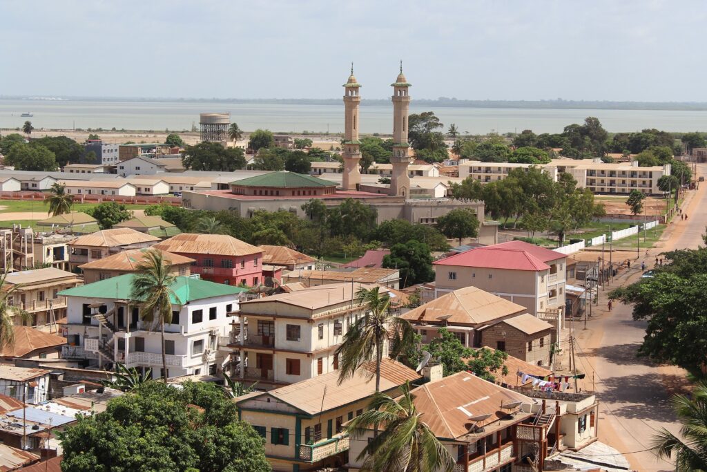
Banjul is the capital of the Gambia and its fourth-largest city. The city is located on Banjul Island and has become a popular tourist destination for European tourists.
Where is Banjul?
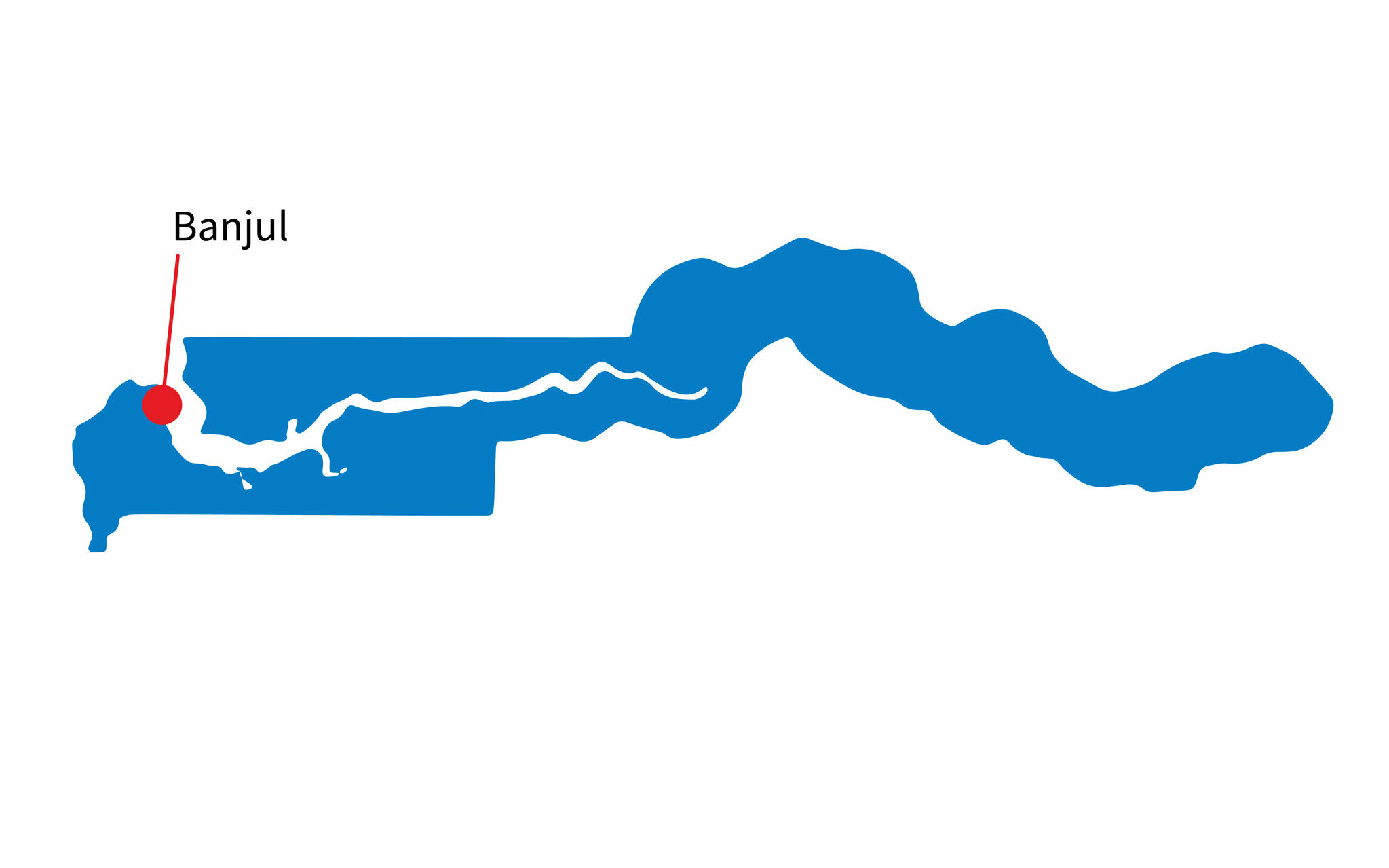
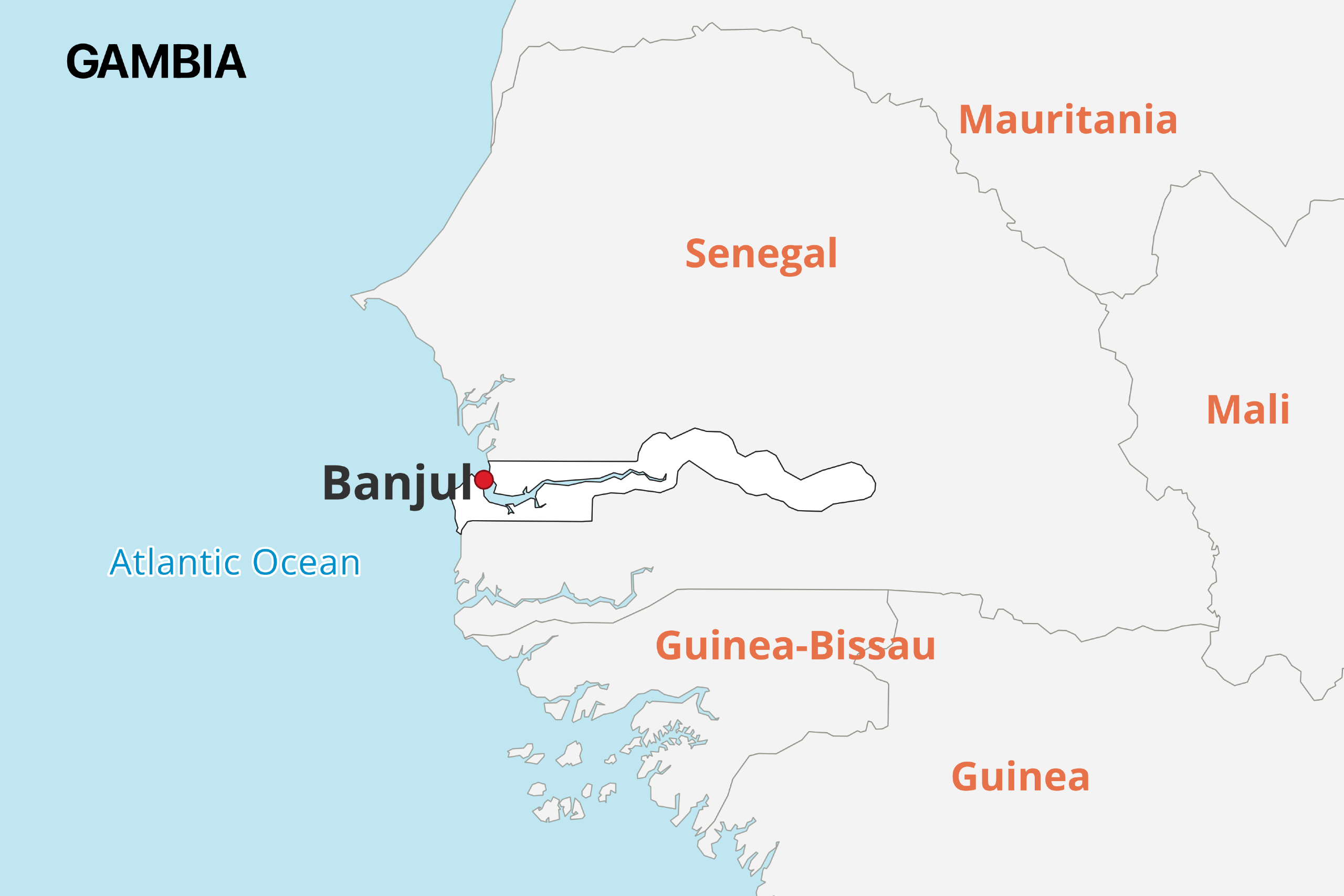
Banjul is located in eastern Gambia on Banjul Island where the Gambia River meets the Atlantic Ocean. The nearest foreign country is Senegal, which is less than 100 km to the north.
When did Banjul Become the Capital?
Banjul became the Gambia capital city in 1965 when the country gained its independence, though it was named Bathurst at the time.
The city was previously named Bathurst after British politician Henry Bathurst in 1816. This was while the area was part of the Gambia Colony and Protectorate controlled by Britain.
During this time, the city was an important center for British trade and military activity. The name was changed to Banjul on 24 April 1973 as part of an Africanization policy.
Features of Banjul
The city of Banjul currently has an estimated population of 34,589 and the Greater Banjul Area is home to more than 413,000 people. It is fairly small compared to other capital cities around the world, but Banjul is Gambia’s most densely populated metropolitan area.
The city of Banjul has an area of only 12 square kilometers, but the greater urban area has a total area of 93 square kilometers. This makes the urban area the largest in the country.
Banjul has a tropical climate. The months between July and October are by far the rainiest and hottest, while there is less rainfall and temperatures are cooler between November and June. On average the air temperature is usually around 25-30C throughout the year.
General Safety in the Capital of Gambia
The highest levels of crime in Banjul are related to corruption and bribery, although there is also significant risk of petty theft. Its good practice to avoid secluded places when alone at night, and to be wary of unlicensed guides offering tours into neighboring Senegal.
It is possible to swim in the waters just off Gambia’s capital city, but it’s important to exercise caution with the open-ocean waves and to watch out for the occasional jellyfish and stingray.
Yellow fever is a disease that is transmitted through mosquito bites and can be found throughout the Gambia, including in its capital. Symptoms of the disease can be severe, but vaccines are widely available and highly effective.
Tap water is considered unsafe to drink in Banjul, Gambia. It is instead advisable to drink bottled drinking water.
In Banjul and Gambia in general, it’s a good idea to get permission before taking pictures of any people. There are some locally held beliefs around photography that can elicit unwanted reactions in people that don’t want their picture taken.
14 Things to See and Do in Banjul

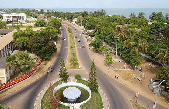
Banjul is known as the most developed city regarding tourism in the Gambia and has the country’s only international airport and major seaport. The city also has many important historical buildings as well as natural beauty.
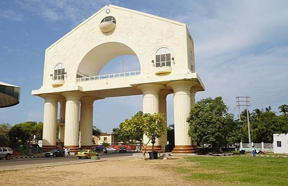
1. Arch 22
This is one of the most recognizable buildings in Banjul, and it can be found on the road leading into the capital city. The building is 35 meters tall, making it one of the largest structures in the Gambia, and it was built in 1996 to commemorate the military coup that took place on July 22, 1994. Near the base of Arch 22 is a statue of an unknown soldier who is carrying a baby and has a rifle strapped to his back.
It’s also possible to visit a small textile museum on the top floor of the museum, and the second floor offers impressive panoramic views. The arch is illustrated on the back of the 100 dalasis banknote.
2. Albert Market
Albert Market is a very busy street market in Banjul. It gets very crowded and is an especially remarkable experience for anyone who hasn’t been to many African street markets. There are vendors selling a very wide range of products here, such as fish, spices, vegetables, and household goods.
3. MacCarthy Square
This Banjul landmark has gone through a couple of name changes in its history. It has been an important center for the city ever since it was established in the 1820s, and was called MacCarthy Square for many years.
In 1996, it was renamed for the date of the military coup that put Lieutenant Yahya Jammeh in power in 1994. Then, the square’s name was changed back in 2018 after the election of Adama Barrow to president of Gambia.
The square has served various uses in the last two hundred years and continues to be a focal point of the city. Two notable features are a World War I memorial and a fountain dating from the 1930s. It’s also regularly used to celebrate national holidays in a grassy, fenced off portion of the square and has been used as a cricket pitch.
4. Eat Seafood
Banjul’s location on the Gambia River and the Atlantic Ocean make it a prime location for enjoying top-quality seafood, and there are plenty of ways to take advantage of what’s on offer.
The easiest way to experience the great seafood to be found in Banjul is to visit one of the many excellent seafood restaurants in the city. There are many to choose from, and some of them are right on the water with great views.
Another great way to experience the diverse seafood in the region is to visit the several stalls selling fish and other seafood at Albert Market. This is a great way to see what fresh fish is currently available.
5. Rent Bicycles
Renting bicycles in Banjul is a great way to see Gambia’s capital city and surrounding area. Traveling by bike is a great way to move at a speed that allows you to see more in a day while making it easy to stop whenever you wish.
It is possible to take guided half- or full-day tours with a tour company to make sure you don’t miss the most interesting sites, but you can also rent a bike from a hotel or rental company and explore on your own.
6. Experience Nature Tours
This is an activity that will lead you outside of Banjul, but there are many tour companies that have their headquarters in the city. The range of tour types is seemingly endless — see birds inland or on the coast, travel to nearby Senegal or stay close to Banjul, spend an afternoon in a nature reserve or go on a multi-week excursion — there’s something for everyone.
Banjul may be a capital city, but it isn’t far from Gambia’s diverse and exciting wildlife.
7. Kachikally Crocodile Pool
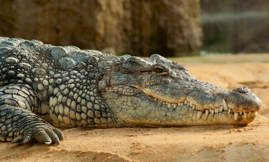
This is a unique experience available to visitors of Banjul, though it’s located just 10 miles outside of the city center. The Kachikally Crocodile Pool is a privately owned park that houses up to 80 crocodiles. It is one of three sacred crocodile pools in the Gambia.
Traditionally, the waters of the pool are thought to help childless couples conceive a child. It is thought that women who bathe in the water will have a better chance of becoming pregnant.
There are a whole host of other animals that can be found at the crocodile pool, such as monkeys and kingfishers. It’s possible for visitors to interact with the crocodiles, although it is important to take the advice of local experts seriously.
8. National Museum
This is Banju’s most notable museum. It was constructed in 1985 after more than two decades of talk and planning for a national museum in the capital city. The museum is focused on collecting and preserving artifacts that represent the cultural heritage of Gambia.
The museum is a great place for anyone interested in learning more about Gambia’s history and culture, and there are also activities that are tailored to children, such as art classes and history video shows.
There are three floors in this museum, and they each have a different focus. On the ground floor, visitors can learn about the political and cultural history of the country. In the basement level, there are instruments and information on the musical heritage of Gambia. The top floor of the museum teaches the archeological history of both Gambia and West Africa in general.
9. King Fahad Mosque
The King Fahad Mosque, or Banjul Central Mosque, is the largest of its kind in the city of Bajul. Construction on the mosque was finished in 1988, and it can accommodate up to 6,000 worshippers.
Mosques are the most commonly found places of worship around Banjul, and this mosque is one of the more impressive works of architecture in the city.
10. Banjul Cathedral
This Roman Catholic Church also goes by the much longer name, Our Lady of the Assumption Cathedral. It is the larger of the two cathedrals in Banjul, and it is located on the corner of the main street in the city.
This place of worship has a long history: it was built between the years of 1913 and 1916, before Gambia had won its independence. The cathedral later became the seat of the Diocese in Gambia in 1957 and remains as such today. The Pope John Paul II visited the Banjul Cathedral in 1992.
11. Bijilo Forest Park
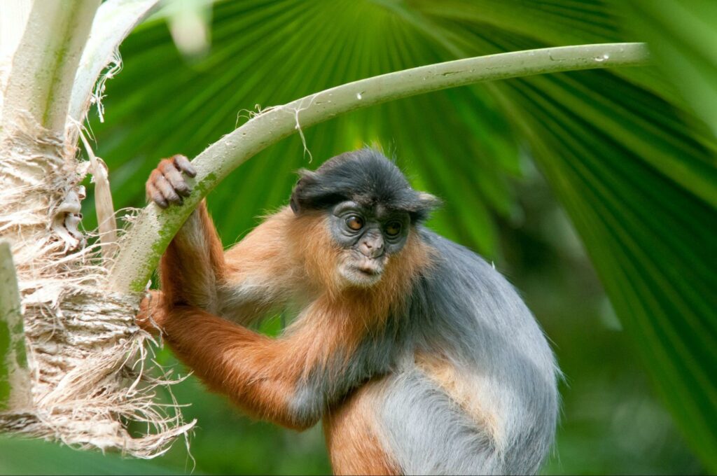
Bijilo Forest Park is also known as Monkey Park and is a favorite among tourists interested in seeing all types of wildlife. The park is just south of the Kololi Beach area on the Atlantic coast in the Greater Banjul Area.
Though it may be most famous for its monkeys, there is a wide variety of animals that live within Bijilo Forest Park, such as African civets, porcupines, monitor lizards, and many different colorful birds and insects. Monkeys in the park have regularly been fed by visitors, which is something the park is trying to discontinue.
The park was made open to the public in 1991 and receives around 23,000 visitors per year. It did have reserve status, but this was revoked in 2018 after the construction of a conference center that took some of the land.
12. Kololi Beach
This is likely the most popular beach among tourists around the area of Banjul. Near the beach, there are many hotels and restaurants that cater specifically to tourists. It’s also home to one of the first hotels in the Gambia, The Senegambia Beach Hotel. The area gets its colloquial name, Senegambia, from this hotel.
Common activities at Kololi Beach include sunbathing, visiting the Senegambia Craft Market, going for a cruise on the Gambia River, or taking a day trip to nearby Bijilo Forest Park. Most of the tourists that travel to this location are from Germany, the UK, Belgium, and the Netherlands.
13. Kotu Beach
Another popular beach among tourists in Gambia’s capital city, Kotu Beach is loved for its sandy beaches, palm trees, and sunsets. The beach gets its name from the nearby Kotu Stream, which feeds into the Atlantic and is also the name of the district.
There are a number of hotels and beach bars that line Kotu Beach, and it is possible to relax in sun chairs underneath umbrellas at one of these establishments or directly on the sand. The beach is also frequented by vendors of all types.
14. Bakau Fish Market
The Bakau Fish Market is another important site near Banjul. It’s where the fishing boats that leave early in the morning come to sell the day’s catch each afternoon. Locals do their seafood trading here, and it’s also a favorite of tourists looking to purchase some local seafood or have an interesting experience.
Like most markets, this one is busy and could prove overwhelming for the unprepared. Many tourists choose to visit the market while accompanied by a guide who can help them navigate the market and find what they’re looking for. You can also see how fish is smoked and salted on the beach here.
Image Sources and Copyright Information
- Banjul gambia capital city mappr maps: © Mappr