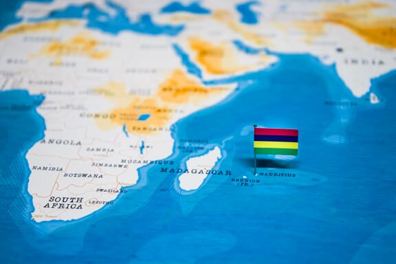
Mauritius is located in the Southern Africa region at latitude -20.348404 and longitude 57.552152 and is part of the African continent.
The DMS coordinates for the center of the country are:
- 20° 20' 54.25'' S
- 57° 33' 7.75'' E
You can see the location of Mauritius on the world map below:

The country has no neighboring countries/land borders.
Maritime Borders
Mauritius borders with the Indian Ocean.
Mauritius Related Content
Mauritius Key Facts
| Country | Mauritius |
| Coordinates | Latitude: -20.348404 Longitude: 57.552152 |
| Country Codes | Alpha 2: MU Alpha 3: MUS |
| Country Flag Emoji | 🇲🇺 |
| Int. Phone Prefix | +230 |
| Capital city | Port Louis |
| Continent Subcontinent | Africa Southern Africa |
| Country Area | 2,040 sq km |
| Population 2021 | 1,266,060 World Rank: 154 |
| Median Age | 36.8 |
| Life expectancy | 73.6 |
| Major languages | Creole 86.5%, Bhojpuri 5.3%, French 4.1%, two languages 1.4%, other 2.6% (includes English, the official language of the National Assembly, which is spoken by less than 1% of the population), unspecified 0.1% (2011 est.) |
| UTC/GMT Time | Number of time zones: 1
|
| Internet TLD | .mu |
| Biggest Airport | Sir Seewoosagur Ramgoolam International Airport (MRU) |
| Average temperature | 22.40 °C 72.32 °F |
| Administrative Divisions | 3 dependencies 9 districts |
| Political system | Parliamentary democracy |
Mauritius Economy Facts
| World Bank Income Group | Upper middle income |
| World Bank Region | Sub-Saharan Africa |
| Currency | Mauritius Rupee (MUR) |
| GDP in 2020 | $10.9 (billions of USD) World Rank: 140 |
| GDP per capita in 2020 | $8,633 World Rank: 72 |
| Major Industries / Economic Sectors | Tourism, manufacturing, agriculture, energy |
| Top 5 Import Countries | China, India, France, United Arab Emirates, South Africa |
| Top 5 Export Countries | United States, China, India, France, United Arab Emirates |
Biggest Cities in Mauritius
Here are the largest cities in Mauritius based on 2021 data:
| City | Population |
|---|
| Curepipe | 299,975 | Port Louis | 149,194 | Quartier Militaire | 22,745 | Centre de Flacq | 15,791 | Port Mathurin | 5,929 | Cap Malheureux | 5,070 |
Map of Mauritius with the Largest Cities
Other Countries in the Southern Africa Region
- Where are the Seychelles?
- Where is Angola?
- Where is Botswana?
- Where is Burundi?
- Where is Eswatini (formerly named Swaziland)?
- Where is Kenya?
- Where is Lesotho?
- Where is Madagascar?
- Where is Malawi?
- Where is Mozambique?
- Where is Namibia?
- Where is Rwanda?
- Where is South Africa?
- Where is South Sudan?
- Where is the Congo?
- Where is Uganda?
- Where is Zambia?
- Where is Zimbabwe?
Image Sources and Copyright Information
- Mauritius Location on Map with Flag Pin: © hyotographics/Shutterstock