Although perhaps best known for coffee and the Amazon Rainforest, South America is a complex continent with a series of distinct but tightly linked political units.
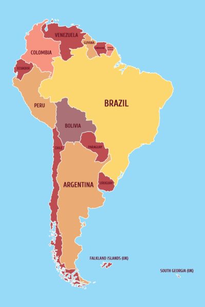
Map of South America
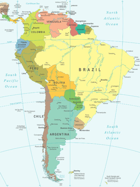
Here’s what you should know about the things that appear on this map of South America.
Continental Overview
The most unusual feature of this map of South America is the low number of cities visible in the central part of the continent. This occurrence is no accident or omission. Instead, this represents one of the largest places in the world that has seen only the most minimal development.
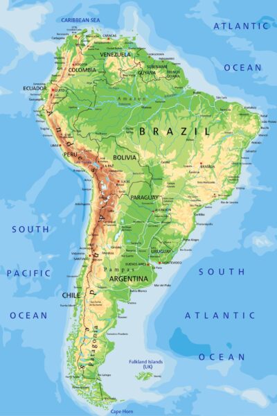
In many respects, the South America political map highlights the unusual reality of the continent’s existence, which is that everything is fundamentally coastal. It isn’t to imply that there are no interior cities, especially in places like Argentina, but rather that the combination of the Amazon Rainforest and the Andes Mountains push most groups to the edge of the map.
The most comparable areas on other maps include western China (largely plateaus and desert) and most of the northern regions of Russia (snowy tundra).
Argentina
- Capital: Buenos Aires is the capital of Argentina
- Currency: Argentine peso
- Language: Spanish (de facto, but not legally, its official language)
- Political System: Federal Presidential Constitutional Republic
- Population: 45 million
Covering most of the eastern side of South America’s southernmost extension, Argentina is one of the continent’s most prominent nations by size and the third-largest by population. It maintains the second-largest economy on the continent. The name itself is derived from the Italian word for “made of silver,” itself a derivative from Latin’s word for silver, “Argentum.”
Argentina is officially a constitutional republic, although several decades of economic and political instability have occasionally caused the rule of law to be set aside. Despite this, it remains a comparatively wealthy country, with soybean and corn products as their primary exports.
Although it primarily uses Spanish as its official language, Argentina has an extremely high amount of Italian ancestry in its population and thus heavy Italian influence on its overall culture. It’s also highly biodiverse, with 15 different continental zones represented across its territory.
Bolivia
- Capital: La Paz and Sucre (Bolivia has split capital cities)
- Currency: Boliviano
- Languages: Spanish, plus several dozen indigenous languages treated as official
- Political System: Unitary Presidential Constitutional Republic
- Population: 11 million
One of South America’s two landlocked countries, Bolivia is a west-central country in South America, with about one-third of its territory set in the Andes mountains. Spanish is the primary official language, but Bolivia recognizes three dozen indigenous languages as official and treats them accordingly.
Somewhat unusually, Bolivia has a split capital system. Sucre is the constitutional capital and seat of the nation’s Supreme Court, while La Paz serves as the general seat of government for Bolivia’s executive and legislative branches.
Bolivia is the fifth-largest country in South America by size and the eighth-largest by population. Its overall economy is considered lower-middle-income for a country, with agriculture, forestry, and fishing serving as mainstays of its economy. It also has a strong mining sector, producing silver, boron, tin, tungsten, and several other valuable metals.
Brazil
- Capital: Brasilia is the capital of Brasil
- Currency: Brazilian Real
- Language: Brazilian Portuguese, Indigenous languages
- Political System: Federal Presidential Constitutional Republic
- Population: 210 million
Brazil is the largest nation on any map of South America, dominating the entire eastern half of the country. It’s also the most populated country, having nearly half the continent’s total population within its borders. The name probably comes from a tree known as Brazilwood, which grew along the country’s coast and was harvested to create a red dye.
A large part of Brazil is framed by the Amazon Rainforest in the North and the Atlantic forest lower down. It has a large indigenous population and its own indigenous languages as well. Family, friendship, and community primarily drive culture in Brazil.
Brazil has a large economy, roughly the 7th largest in the world total, although per capita, it’s only 82nd. The gross domestic product rate (GDP) per capita was once the largest in South America, but slowly gave way to Chile and Peru.
It primarily relies on exports, with iron ore, crude petroleum, soybeans, and raw sugar as the largest sectors of its economy.
Outside of its other exports, Brazil is famously the world’s largest exporter of coffee, selling about 40% of the world’s total annual supply (and producing 3% of the country’s revenue). About 70% of their coffee beans are the higher-quality Arabica, with the remainder grown as the cheaper but lower-quality Robusta beans.
Chile
- Capital: Santiago is the capital of Chile
- Currency: Chilean Peso
- Language: Spanish
- Political System: Unitary Presidential Constitutional Republic
- Population: 17 million
Chile is a long and slender nation on the Pacific side of South America’s southern extension. Its widest point is just 221 miles, stretching over 2600 miles from north to south. This shape makes it one of the world’s most unusually-shaped nations, as most countries trend towards a more even rectangle.
The entire country is heavily mountainous, especially along its northern and eastern sides. It tapers off somewhat along the south and west coasts, where lower elevation provides most of the country’s wetter and more generous living spaces. The population is heavily urbanized, with 85% living in cities and 40% in the greater Santiago area near the country’s middle.
Chile’s economy is generally stable, with copper mining serving as the core of its exports. The country also sells pitted fruits, fish, wine, wood pulp, and some other products. Tourism is also popular, with warmer coastal areas being trendy.
Chile technically claimed part of Antarctica as its territory and signed the Antarctic Treaty, which suspends its claim to the area as long as the treaty is in force.
Colombia
- Capital: Bogotá is the capital of Colombia
- Currency: Colombian Peso
- Languages: English, Portuguese, Spanish, and many others
- Political System: Unitary Presidential Constitutional Republic
- Population: 50 million
Although not one of South America’s largest countries, Colombia is the country’s second most populated, with about 11.7% of the overall population. It also is the only country in South America with land access to another continent. Its northwest neighbor Panama is traditionally considered the southernmost part of North America.
Colombia has some mountainous regions on its western side but has access to both Pacific and Caribbean coastal plains and some territory in the Amazon Rainforest. Colombia is exceptionally biodiverse in its plants and wildlife, usually coming in first or second worldwide depending on the metrics used.
Colombia exports large amounts of petroleum and coal briquettes as a mainstay of its economy. It’s also a major producer of coffee, which represents a little under 6% of its total exports. Colombian coffee is often considered very high-quality, primarily when grown in mountain areas, making it particularly well-known through that export.
Ecuador
- Capital: Quito is the capital of Ecuador
- Currency: United States Dollar
- Languages: Spanish, plus several indigenous languages
- Political System: Unitary Presidential Constitutional Republic
- Population: 17 million
Ecuador is a relatively small country on the northwestern side of South America, nestled between Colombia and Peru. Its population matches its size, roughly in the middle of all South American countries.
Ecuador has four primary geographic areas, including the coast, the highlands, and some of the Amazon rainforest. Ecuador also claims the Galápagos Islands, several hundred miles off the coast, as an additional region for their country. The climate varies by area but is broadly steady within those places, seeing little change in daylight hours or temperature throughout the year.
Economically, Ecuador relies heavily on commodities, including petroleum, bananas, crustaceans, and fish, as significant exports. Cocoa beans are a relatively small part of their economy, comprising roughly 3% of their exports, but provide a substantial amount of the beans used for making chocolate worldwide.
Falkland Islands
- Capital: Stanley
- Currency: Falkland Islands Pound
- Language: English
- Political System: Devolved Parliamentary Dependency, under Constitutional Monarchy
- Population: 3,300
The Falkland Islands are easily the smallest territory in South America. Set off the eastern coast of Argentina, the Falkland Islands have just a few thousand residents. Most people live relatively close to the capital of Stanley, but the country has over seven hundred other islands within its territory.
The Falkland Islands have a high level of internal self-governance but are functionally a British overseas territory. As a result, the United Kingdom manages its national defense and foreign affairs, which is notable given that Argentina also claims the islands and has occasionally invaded them to try and seize them by force.
Fisheries represent an overwhelmingly large part of its economy and exports, with wool as the distant but next-closest competitor.
French Guiana
- Capital: Paris in France is the capital of French Guiana
- Currency: Euro
- Languages: French, several local languages
- Political System: Unitary Semi-Presidential Constitutional Republic
- Population: 294,000 (local)
French Guiana isn’t a country like other parts of South America. Instead, it’s a whole part of the French Republic, which means it’s also part of the European Union. More specifically, French Guiana is the second-largest region in all of France. It has a local assembly to address some local issues, but its primary laws and frameworks are French.
Most of the area’s population lives along the coastal strip on the area’s northern side. The interior of French Guiana is primarily mountains and rainforests, with a significant part of it designated as part of one of France’s national parks.
While it’s difficult to separate the area’s economy from mainland France, the territory exports seafood, gold, rice, and some tools.
Guyana
- Guyana Capital: Georgetown
- Currency: Guyanese Dollar
- Languages: English, 10 indigenous languages
- Political System: Unitary Assembly
- Population: 743,000
Set in the middle of South America’s northern side, Guyana is a small nation by territory and the country’s eleventh-largest by population, representing just 0.18% of the people. Most citizens live in a narrow fertile area along the Atlantic coast.
Although sparsely populated at best, Guyana is notable for being the home of Kaieteur Falls, which is the world’s largest single-drop waterfall by its volume. About 23,400 cubic feet of water go over it each second, and it’s more than four times taller than Niagara Falls.
Paraguay
- Capital: Asuncion
- Currency: Guarani
- Languages: Guarani and Spanish
- Political System: Unitary Presidential Republic
- Population: 7 million
Paraguay is South America’s second landlocked country, to the east and a bit smaller than its similarly-situated neighbor Bolivia. It has two primary geographic regions, split by the Paraguay River. Unlike some other parts of South America, the general lack of mountains in the area means wind speeds can get relatively high, and temperatures can change quickly.
Paraguay’s economy relies heavily on soybeans and meat, although it also sells electricity throughout the area through clean hydropower projects. Though technically landlocked, its river access means it can still reach the ocean for more straightforward international trade.
Peru
- Capital: Lima
- Currency: Sol
- Languages: Spanish, several indigenous languages
- Political System: Unitary Presidential Republic
- Population: 34 million
Peru is one of the larger countries in South America, with the fourth-highest population on the continent. It has a generally prosperous economy, a fast industrial growth rate, and a broad mix of cultural traditions apparent in its food and music.
Mining makes up a significant part of its economy, with copper, lead, zinc, and gold as major segments. Peru also sells some animal and fruit products, although they aren’t quite central to its economy.
Suriname
- Capital: Paramaribo
- Currency: Surinamese Dollar
- Languages: Dutch, several indigenous languages
- Political System: Unitary Assembly
- Population: 576,000
Suriname is a little-known country set on South America’s northern coast, between Guyana and French Guiana. About half of its population lives in and around its capital, and it has extensive connections to the Netherlands that remain after its colonial history.
Economically, mining is an essential factor, with aluminum ore and gold serving as pillars of operations. Suriname also exports some food products, including rice and bananas, but these are a comparatively small part of its economy.
Uruguay
- Capital: Montevideo
- Currency: Uruguayan Peso
- Languages: Uruguayan Portuguese
- Political System: Unitary Presidential Constitutional Republic
- Population: 3 million
Uruguay is a relatively small country on South America’s southeastern side. It’s bordered directly by Brazil to the north and east and Argentina to the west. Today, Uruguay has a strong economy with low levels of corruption and high rankings on measurements for personal rights and overall prosperity.
Uruguay is highly temperate, with similar weather throughout much of the year. Its economy exports many meat and plant products, and despite some border disputes with Brazil, Uruguay generally has friendly relations with its giant neighbor.
Venezuela
- Capital: Caracas is the capital of Venezuela
- Currency: Venezuelan Bolivar
- Languages: Spanish, several dozen indigenous languages
- Political System: Federal Presidential Constitutional Republic
- Population: 28 million
Venezuela is one of the largest South America map countries, both in territory size and by population. However, long-recognized as a significant oil exporter, economic issues in recent years have primarily collapsed Venezuela’s economy and driven hyperinflation, unemployment, and an ongoing migrant crisis.
Petroleum makes up more than 80% of Venezuela’s exports and thus dominates the economy, but they also sell acrylic alcohols and some amounts of iron and gold.
More Maps of South America Maps
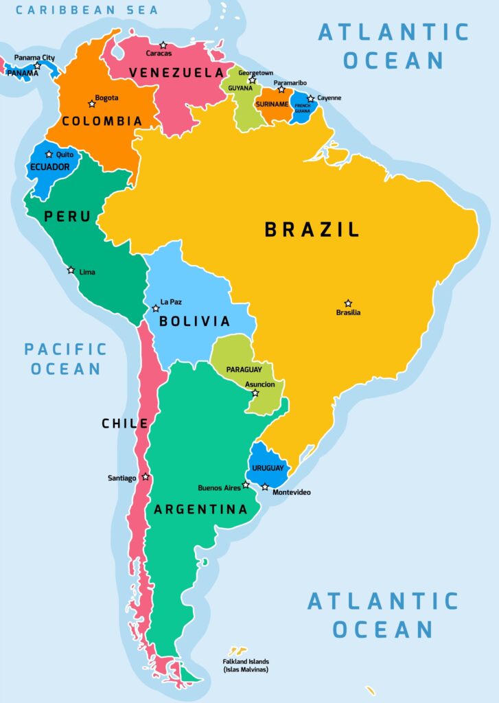
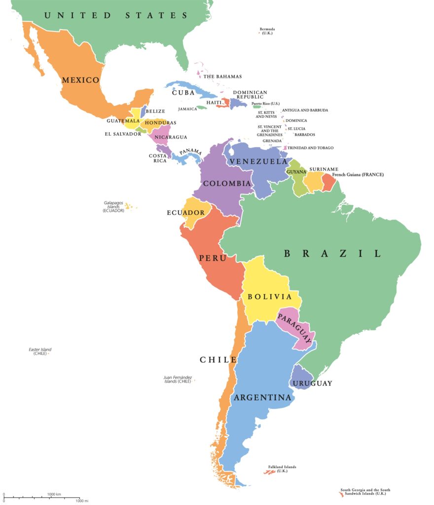
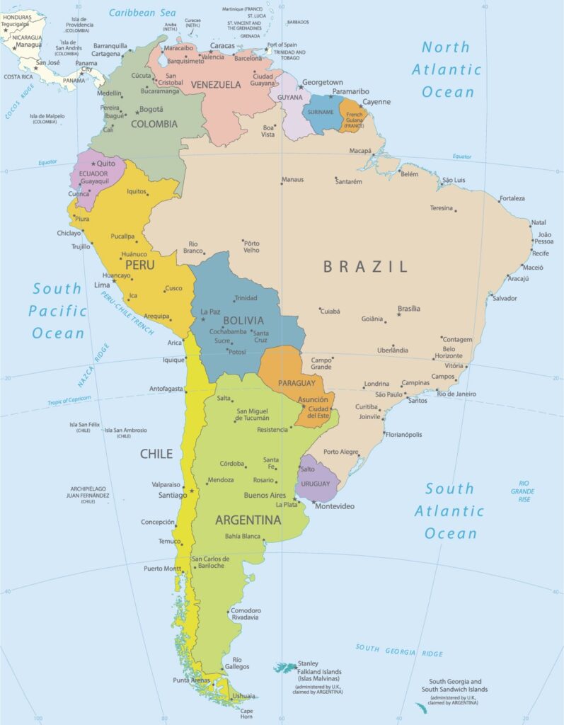
Image Sources and Copyright Information
- Colorful Political Map of South America: Wikipedia | Public Domain Mark 1.0
- South America Physical Map with Labels: © Bardocz Peter/Shutterstock
- Colorful Map of South America with Country Names: © Iryna Shorokhova/Shutterstock
- Political Map of South America: © Tupungato/Shutterstock
- Colorful Political Map of South America: © Peter Hermes Furian/Shutterstock
- Highly Detailed Political Map of South America: © ekler/Shutterstock