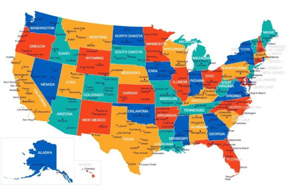
USA Political Map with Cities

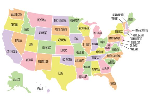
The above color-coded map of the USA shows each of the 50 states in the country along with the capital of each state and other major US cities.
How well do you know the United States? Take our new US States Quiz to find out!
The United States – General Overview, Demographics
Table of Contents
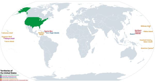
The United States of America is a country located mostly in North America that consists of 50 states, a federal district, and several territories. Its only land borders are shared with Canada and Mexico.

With a total area of 9,833,520 square kilometers (3,796,742 square miles) and a 2022 population estimate of 332,403,650 people, the USA is the world’s third-largest and third most populous country. It also plays a prominent role in global politics and has the world’s largest economy measured by nominal GDP.
The USA also makes important cultural, technological, and scientific contributions that have an international impact. Manufacturing techniques and mass production methods developed in the US have been utilized globally, and the country had the second-highest number of scientific papers published in 2020 after China. Music and movies are some of the USA’s most popular cultural exports, reaching countries all over the world.
Demographics
Due to the country’s relatively young age and high levels of immigration, the United States is a very diverse country. The land of the present-day USA was inhabited by people indigenous to the area for thousands of years prior to the arrival of European explorers who colonized the land.
The largest ancestry group in the USA is White Americans of European, Hispanic, or Latino ancestry, which makes up about 73% of the population. Among this group, the European countries most represented are Germany, England, Ireland, Poland, France, and Italian. White Mexican Americans make up the largest portion of the White Hispanic or Latino group.
The largest minority ancestry group in the United States is African American, accounting for roughly 13% of the country’s population. Asian Americans make up the second-largest minority group in the nation, about 7% of the US population.
Geography
The USA has a high level of geographical diversity thanks to its size and access to two major oceans. There are high mountain ranges, vast deserts, abundant forests, rolling hills, grasslands, major river systems, massive lakes, and more. Much of the country’s beautiful landscape is protected by 423 national parks.
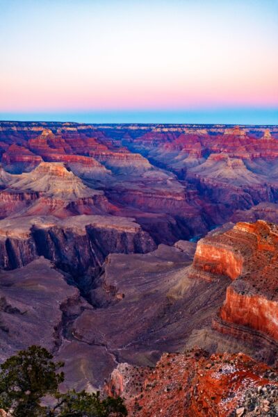
Some of the most iconic places in the USA are the Grand Canyon in Arizona, Arches National Park in Utah, and Yellowstone National Park. The golden sand beaches of California, the mountains and glaciers of Alaska, and the tropical beaches of Hawaii are also impressive locations that attract tourists.

The US is among the countries with the longest coastlines in the world because of its access to the Pacific, Atlantic, and Arctic Oceans as well as the Gulf of Mexico. The Great Lakes Region of the United States also has the world’s largest supply of fresh water. The country’s largest state is Alaska and its smallest is Rhode Island.
According to the US Census Bureau, there are five different US regions, each of which has its own unique characteristics.
Western USA
The Western United States is the largest region by area, and contains most of the country’s deserts. It also features a long coastline on the Pacific Ocean and includes California, the most populous state in the nation. It also borders Canada to the north and Mexico to the south.
Southeastern USA
Part of the greater Southern region as described by the US Census Bureau, the Southeastern USA is made up of 13 states and is known for sunny climes as well as occasionally extreme weather such as hurricanes. The region borders the Atlantic Ocean to the east and the Gulf of Mexico to the south.
Northeastern USA
One of the most-visited areas in the country is the Northeastern USA. It’s an area that is full of US history and iconic cities like New York. This is also where the Ivy League schools are located and is famous for its seafood. The region borders Canada to the north and the Atlantic Ocean to the east.

Midwestern USA
Also known as “America’s Heartland” the Midwestern US is a region known for its agricultural production as well as its manufacturing activities. The area is populated by a number of smaller cities and towns connected by highways but also features larger cities like Chicago and Minneapolis. This part of the United States borders Canada to the north as well as the Great Lakes.
Southwestern USA
The Southwestern US is a region of the country that borders Mexico to the south and extends across five states. The area is characterized by an arid climate and hot deserts, and it is known for having its own cuisine and architectural style. The largest city in this region is Las Vegas, famous for its many luxury resorts and casinos.
The US Economy
With a nominal GDP of over $20 trillion, the USA has the largest economy in the world and accounts for almost a quarter of the global GDP. It is also the world’s largest importer and second-largest exporter, trading primarily with Canada, China, Japan, Mexico, and the European Union. Despite making up just over 4% of the world’s population, Americans hold almost 30% of the world’s wealth.
A large portion of the country’s economy is tied to its military. The USA spends more on military (over $800 billion) than the next nine countries combined. This makes up for more than 10% of all federal spending.
The United States also has a large job market, with the state of California having the strongest job market. The largest employment sectors in the country are public schools, hospitals, and the service industry.
The most valuable natural resource in the USA is oil and natural gas, of which the US is the world’s leading producer. Agriculture is another important part of the US economy, and the states of California, Iowa, Texas, and Nebraska make up the richest agricultural areas in the country.
The Largest US States
As one of the world’s largest countries, the USA has plenty of states that are larger than many other countries. Of these, Alaska is the largest, and California is the most populous.
Top Ten States by Area
| State | Total Area |
| 1. Alaska | 1,723,337 km2 (665,384 mi2) |
| 2. Texas | 95,662 km2 (268,596 mi2) |
| 3. California | 423,967 km2 (163,695 mi2) |
| 4. Montana | 380,831 km2 (147,040 mi2) |
| 5. New Mexico | 314,917 km2 (121,590 mi2) |
| 6. Arizona | 295,234 km2 (113,990 mi2) |
| 7. Nevada | 286,380 km2 (110,572 mi2) |
| 8. Colorado | 269,601 km2 (104,094 mi2) |
| 9. Oregon | 254,799 km2 (98,379 mi2) |
| 10. Wyoming | 253,335 km2 (97,813 mi2) |
Top Ten States by Population
| State | 2022 Population Estimate |
| 1. California | 39,613,493 |
| 2. Texas | 29,730,311 |
| 3. Florida | 21,944,577 |
| 4. New York | 19,299,981 |
| 5. Pennsylvania | 12,804,123 |
| 6. Illinois | 12,569,321 |
| 7. Ohio | 11,714,618 |
| 8. Georgia | 10,830,007 |
| 9. North Carolina | 10,701,022 |
| 10. Michigan | 9,992,427 |
Wyoming and Vermont are the US states with the smallest populations.
The Largest Metropolitan Areas
The United States is also home to some of the largest metropolitan areas in the world. New York, Los Angeles, Chicago, Dallas, and Houston are the five largest in the country, and they each have populations of over 7 million people. They New York-Newark-Jersey City metro area is the largest with a population of over 19 million.
Washington DC, Philadelphia, Atlanta, Boston, and San Francisco are the five next largest metro areas.
Travel and Tourism in the United States
With plenty of reasons to visit the United States, there’s no wondering why it ranks among the top-visited countries in the world. With around 80 million tourists coming to the country in a year, it is the world’s third-most visited country. Some of the world’s most visited cities are located here: New York, Miami, Los Angeles, Orlando, and San Francisco are a few.
As with everywhere in the world, the tourism industry in the USA experienced a significant decline in 2020 due to the COVID-19 Pandemic, and it is still recovering. In 2019, before the onset of the pandemic, tourism generated almost $240 billion in revenue. In 2020, that number dropped to just over $84 billion, but it is expected to continue increasing.
In addition to its world-famous cities, the extensive highway network and patchwork of small towns across the USA attract tourists that are looking to experience the country by car. Road trips are a staple of American culture and something that attracts both domestic and international tourists.
The natural wonders of the United States are another reason so many people travel to the USA each year. Some of the most popular natural attractions in the country are the Grand Canyon, Niagara Falls, Yellowstone National Park, Arches National Park, and Glacier National Park.
Other popular attractions include the Statue of Liberty, Central Park and Times Square in New York, Walt Disney World Resort, the Las Vegas Strip, the Mount Rushmore National Memorial, and the White House.
Image Sources and Copyright Information
- Colorful USA Political Map with State Names: © Anna Marin N/Shutterstock
- Colorful Map of USA with States and Major Cities: © Porcupen/Shutterstock
- Map Highlighting United States Territories: © Peter Hermes Furian/Shutterstock
- Sunset at Hopi Point, Grand Canyon: © John Gress Media Inc/Shutterstock
- New York City Skyline at Dusk: © littlenySTOCK/Shutterstock